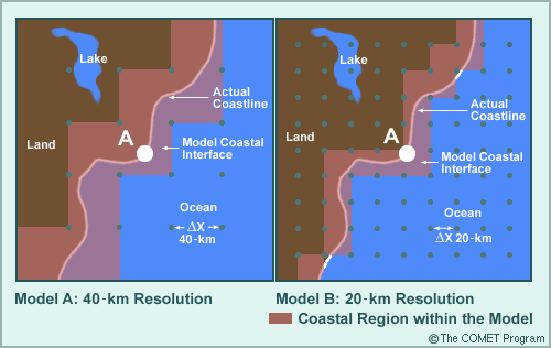
Impacts of Model Topography » Land/water Interface Considerations

Models also have difficulty resolving features influenced or caused by the interface between land and large bodies of water. This includes oceanic coastal regions and those near the large lakes. Since the properties of land and water are so different, a model will do a poor job of representing the processes that occur or are influenced by land/water interfaces if its resolution is not sufficient to determine their location. For example, models may not place the land/sea interface in the proper location or adequately define its boundary. Smaller lakes are only recognized by very fine-resolution meso- and local-scale models and are not represented in most operational models.
In the example, the coastline in models A and B falls within the purple-shaded regions. In model A, the water/land interface falls within a 40-km band in most areas, the irregularities of the actual coastline are not well represented, and the lake is not recognized at all. In model B, the water/land interface falls within a 20-km band in most places, the actual coastline irregularities are better represented, and three grid points identify the lake.
Question 1 of 2
How will an increase in the model resolution from 40 km to 20 km change how the model will handles sea breezes.
The correct answer is a.
A better resolved land/sea interface will take into account temperature differences across the coastal region, which drive the sea breeze.
Question 2 of 2
How will an increase in the model resolution from 40 km to 20 km most likely change the average summer maximum temperatures at the point marked A?
The correct answer is b.
A better resolution of the sea breeze, will most likely, reduce the daily maximum temperature and hence the average summer temperature.