Produced by The COMET® Program
- Introduction
- Hydrostatic vs Non-hydrostatic Models
- Gridpoint vs Spectral Data Representation
- Exercises
- Model Type Summary
- Vertical Coordinates
- Model Resolution
- Impacts of Model Topography
- Vertical Resolution
- Domain and Boundary Conditions
- Tasmanian Case Study
- Summary
- Contributors
Vertical Coordinates » Hybrid coordinates
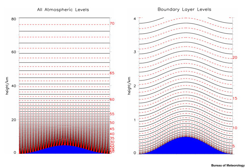
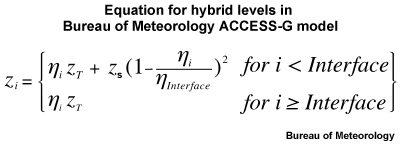
Hybrid vertical coordinate systems combine two coordinate system in a seamless manner, between terrain following coordinates near the surface to constant geopotential surfaces in the upper atmosphere. The levels and related equations shown are for the ACCESS model, where zi is the geopotential height above mean sea level of model level i, zT is the geopotential height at the top of the model, zS is the terrain height above mean sea level, ηi is the "eta" value of model level i and ηInterface is the "rho"-level η value at i = Interface.
Models like the ECMWF use sigma and pressure levels.
© Copyright 2015, The University Corporation for Atmospheric Research.
All Rights Reserved. Legal Notices.