Vertical Coordinates » Sigma Coordinates

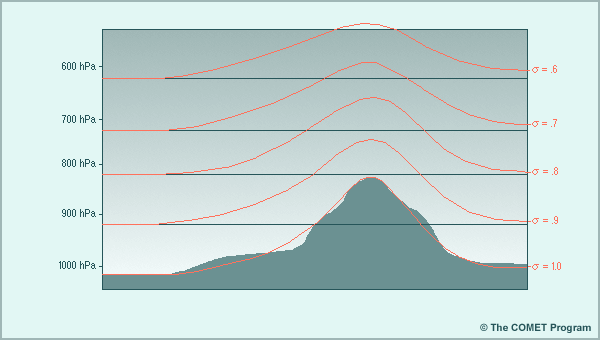
Pressure coordinate systems are not particularly suited to solving the forecast equations because they can intersect mountains and consequently 'disappear' over parts of the forecast domain. In order to solve this problem, the sigma coordinate is terrain following.
The sigma coordinate is defined by σ = p/ps, where p is the pressure on a forecast level within the model and ps is the pressure at the earth's surface, not mean sea level pressure. The lowest coordinate surface (usually labeled σ = 1) follows a smoothed version of the actual terrain. Note that the terrain slopes used in sigma models are always smoothed to some degree. The other sigma surfaces gradually transition from being nearly parallel to the smoothed terrain at the bottom of the model (σ = 1) to being nearly horizontal to the constant pressure surface at the top of the model (σ = 0). The top layer of the model is typically placed well above the tropopause.