Media Gallery
Media elements used in this module are protected by a variety of copyright licenses. Please use the "copyright terms" link associated with each item below for more information.

Description:
moisture plume
File Name:
10gdptwv.gif
Credits:
© The COMET Program
Copyright Terms:
COMET Standard Terms of Use
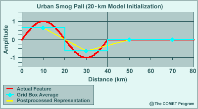
Description:
urban smog pall
File Name:
2gdptwv.gif
Credits:
© The COMET Program
Copyright Terms:
COMET Standard Terms of Use
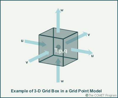
Description:
3-D grid box
File Name:
3dcube.gif
Credits:
© The COMET Program
Copyright Terms:
COMET Standard Terms of Use
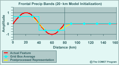
Description:
frontal precip bands
File Name:
4gdptwv.gif
Credits:
© The COMET Program
Copyright Terms:
COMET Standard Terms of Use

Description:
A model grid
File Name:
50kmgrid.gif
Credits:
© The COMET Program
Copyright Terms:
COMET Standard Terms of Use
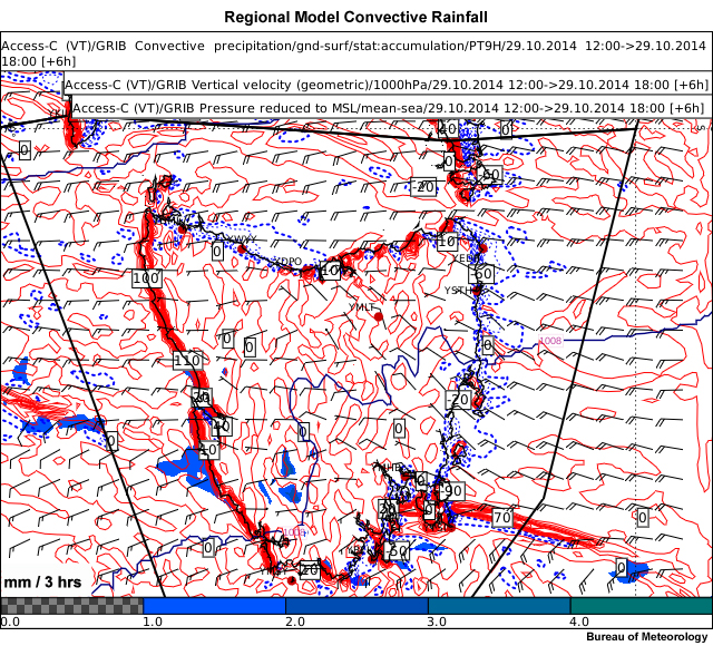
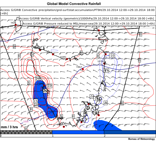
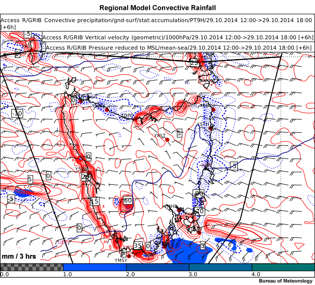
Description:
Convective rainfall, surface wind and surface vertical motion for the Bureau of Meteorology ACCESS-C regional model with a horizontal resolution of ~4km.
File Name:
accessc-tas-convpptn.jpg
Credits:
Bureau of Meteorology
Copyright Terms:
COMET Standard Terms of Use
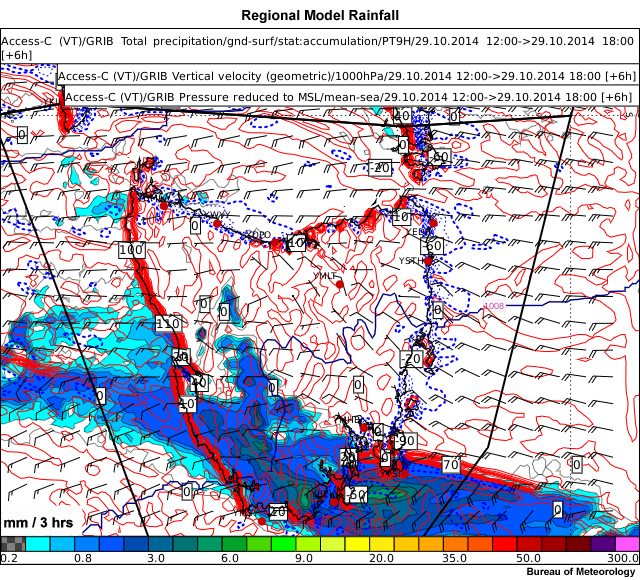
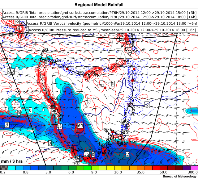
Description:
Total rainfall, surface wind and surface vertical motion for the Bureau of Meteorology ACCESS-C regional model with a horizontal resolution of ~4km
File Name:
accessc-tas-pptn-w.jpg
Credits:
Bureau of Meteorology
Copyright Terms:
COMET Standard Terms of Use

Description:
Wind change location for ACCESS-R wind field.
File Name:
accessc-tas-pptn-w_feedback.jpg
Credits:
Bureau of Meteorology
Copyright Terms:
COMET Standard Terms of Use

Description:
Convective rainfall, 10m winds and vertical motion from the Bureau of Meteorology ACCESS model.
File Name:
accessg-convdar.jpg
Credits:
Bureau of Meteorology
Copyright Terms:
COMET Standard Terms of Use
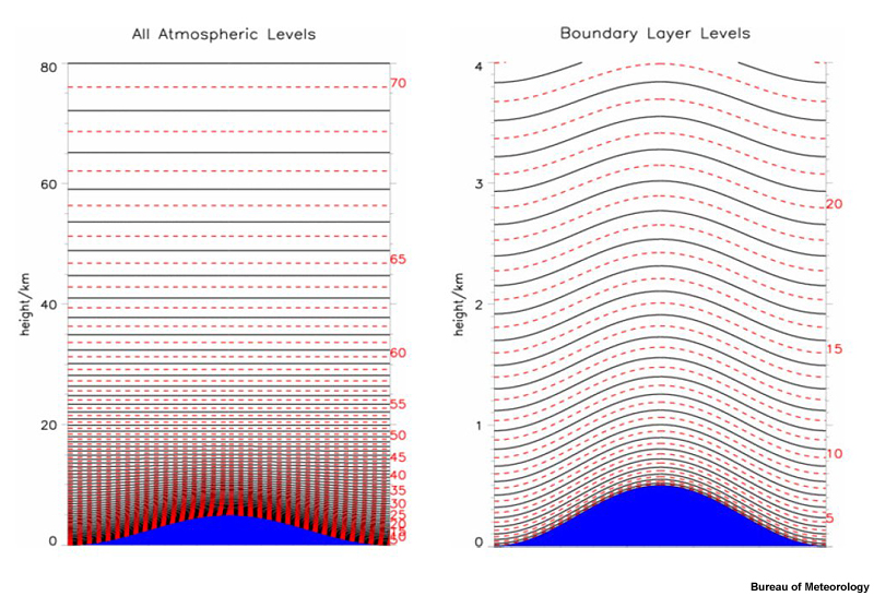
Description:
Hybrid coordinates in ACCESS-G
File Name:
accessg-hybridlevels.jpg
Credits:
Bureau of Meteorology
Copyright Terms:
COMET Standard Terms of Use
Description:
Convective rainfall, surface wind and surface vertical motion for the Bureau of Meteorology ACCESS-G global model with a horizontal resolution of ~40km
File Name:
accessg-tas-convpptn.jpg
Credits:
Bureau of Meteorology
Copyright Terms:
COMET Standard Terms of Use
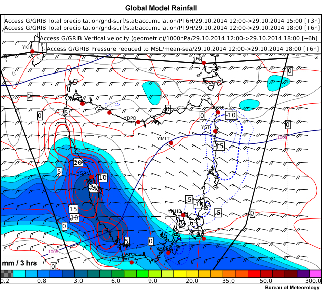
Description:
Total rainfall, surface wind and surface vertical motion for the Bureau of Meteorology ACCESS-G global model with a horizontal resolution of ~40km.
File Name:
accessg-tas-pptn-w.jpg
Credits:
Bureau of Meteorology
Copyright Terms:
COMET Standard Terms of Use

Description:
Convective rainfall, 10m winds and vertical motion from the Bureau of Meteorology ACCESS model.
File Name:
accessr-convdar.jpg
Credits:
Bureau of Meteorology
Copyright Terms:
COMET Standard Terms of Use
Description:
Convective rainfall, surface wind and surface vertical motion for the Bureau of Meteorology ACCESS-R regional model with a horizontal resolution of ~12km.
File Name:
accessr-tas-convpptn.jpg
Credits:
Bureau of Meteorology
Copyright Terms:
COMET Standard Terms of Use
Description:
Total rainfall, surface wind and surface vertical motion for the Bureau of Meteorology ACCESS-R regional model with a horizontal resolution of ~12km
File Name:
accessr-tas-pptn-w.jpg
Credits:
Bureau of Meteorology
Copyright Terms:
COMET Standard Terms of Use
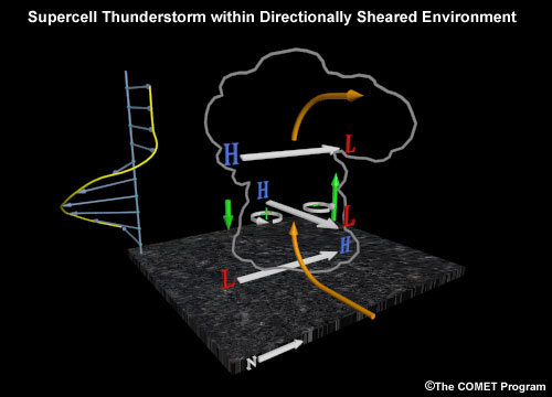
Description:
Updraft shear interactions
File Name:
anomalous_motion_directional_splits.jpg
Credits:
© The COMET Program
Copyright Terms:
COMET Standard Terms of Use
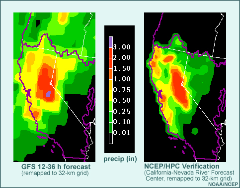
Description:
GFS and NCEP/HPC Verification
File Name:
apcpverf.jpg
Credits:
© The COMET Program
Copyright Terms:
COMET Standard Terms of Use
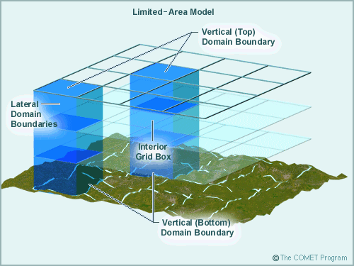
Description:
limited area model
File Name:
bndrycub.gif
Credits:
© The COMET Program
Copyright Terms:
COMET Standard Terms of Use
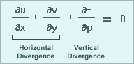
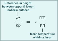
Description:
Continuity equation
File Name:
conteqn.gif
Credits:
© The COMET Program
Copyright Terms:
COMET Standard Terms of Use

Description:
Grid spacing equivalent for spectral model
File Name:
deltax1.gif
Credits:
© The COMET Program
Copyright Terms:
COMET Standard Terms of Use
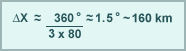
Description:
Grid spacing equivalent for spectral model example
File Name:
deltax2.gif
Credits:
© The COMET Program
Copyright Terms:
COMET Standard Terms of Use
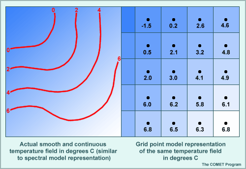
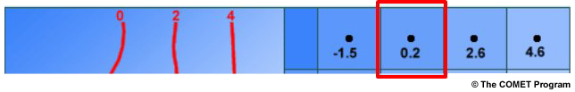
Description:
Grid point model representation
File Name:
gdspctmp.gif
Credits:
© The COMET Program
Copyright Terms:
COMET Standard Terms of Use
Description:
Difference between gradient for smooth field and grid point representation
File Name:
gridgradient.jpg
Credits:
© The COMET Program
Copyright Terms:
COMET Standard Terms of Use
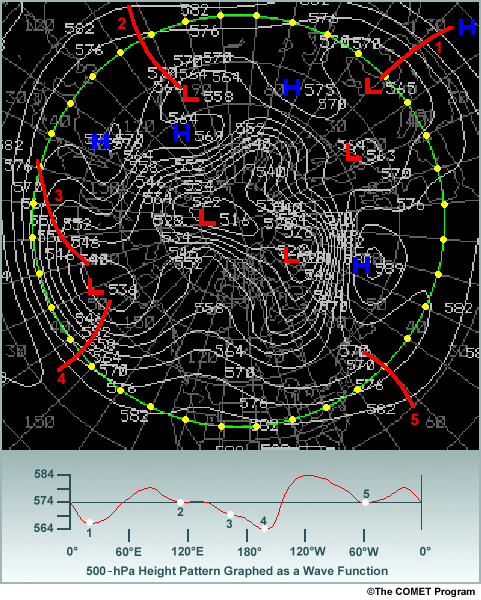
Description:
500 hPa height pattern wave representation
File Name:
hemspec.gif
Credits:
© The COMET Program
Copyright Terms:
COMET Standard Terms of Use
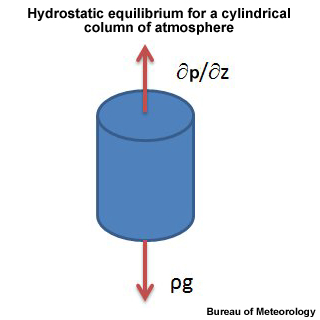
Description:
Hydrostatic equilibrium
File Name:
HSE.jpg
Credits:
Bureau of Meteorology
Copyright Terms:
COMET Standard Terms of Use
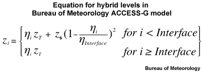
Description:
Hybrid coordinates in ACCESS-G
File Name:
hybrideqs.jpg
Credits:
Bureau of Meteorology
Copyright Terms:
COMET Standard Terms of Use
Description:
Hydrostatic equation
File Name:
hydroeqn.gif
Credits:
© The COMET Program
Copyright Terms:
COMET Standard Terms of Use
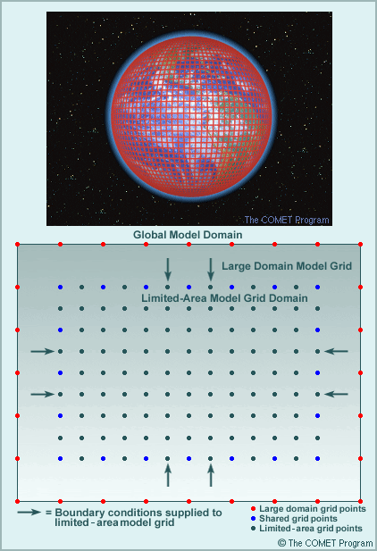
Description:
Global model domain
File Name:
limglobl.gif
Credits:
© The COMET Program
Copyright Terms:
COMET Standard Terms of Use
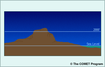
Description:
image showing sea level and mountain top
File Name:
lyrmtn.jpg
Credits:
© The COMET Program
Copyright Terms:
COMET Standard Terms of Use

Description:
MCS development
File Name:
mcs30grd.gif
Credits:
© The COMET Program
Copyright Terms:
COMET Standard Terms of Use
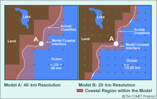
Description:
40 km and 20 km resolution model output
File Name:
mdlcoast.gif
Credits:
© The COMET Program
Copyright Terms:
COMET Standard Terms of Use

Description:
Wind over mountain vs. wind of small hill
File Name:
mdlterfs.jpg
Credits:
© The COMET Program
Copyright Terms:
COMET Standard Terms of Use

Description:
Wind over mountain vs. wind of small hill
File Name:
mdlterfs_quest.jpg
Credits:
© The COMET Program
Copyright Terms:
COMET Standard Terms of Use
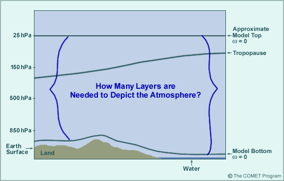
Description:
How many layers are need to depict the atmosphere?
File Name:
modvert2.gif
Credits:
© The COMET Program
Copyright Terms:
COMET Standard Terms of Use
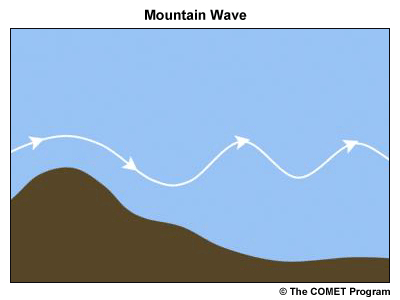
Description:
Mountain wave
File Name:
mountainwave.gif
Credits:
© The COMET Program
Copyright Terms:
COMET Standard Terms of Use
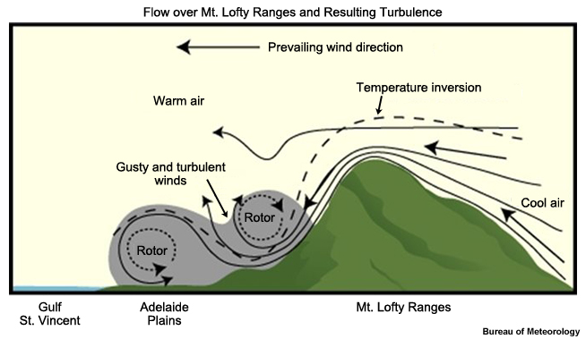
Description:
Flow over Mt Lofty Ranges
File Name:
mtlofty.jpg
Credits:
Bureau of Meteorology
Copyright Terms:
COMET Standard Terms of Use
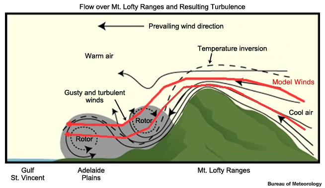
Description:
Flow over Mt Lofty Ranges with model winds overlaid
File Name:
mtlofty_mod_winds.jpg
Credits:
Bureau of Meteorology
Copyright Terms:
COMET Standard Terms of Use
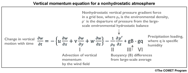
Description:
Vertical momentum equation
File Name:
nonHSE.jpg
Credits:
© The COMET Program
Copyright Terms:
COMET Standard Terms of Use

Description:
Vertical momentum equation
File Name:
nonHSE-labeled.jpg
Credits:
© The COMET Program
Copyright Terms:
COMET Standard Terms of Use

Description:
Vertical layers of atmosphere
File Name:
nwpcncpt.jpg
Credits:
© The COMET Program
Copyright Terms:
COMET Standard Terms of Use
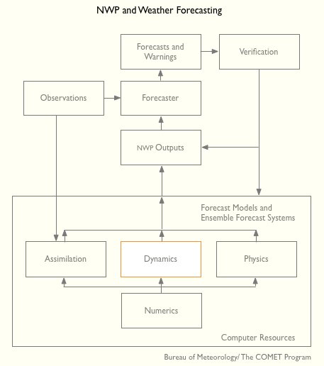
Description:
Chart of the NWP and Weather forecast process highlighting Dynamics
File Name:
nwp_graph_dynamics.gif
Credits:
©The COMET Program
Copyright Terms:
COMET Standard Terms of Use

Description:
850 hPa omega
File Name:
omega850.jpg
Credits:
Bureau of Meteorology
Copyright Terms:
COMET Standard Terms of Use
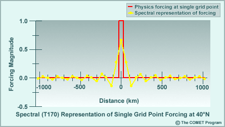
Description:
Spectral Representation of Single Grid Point Forcing
File Name:
physring.gif
Credits:
© The COMET Program
Copyright Terms:
COMET Standard Terms of Use

Description:
Radar pattern for a MCS
File Name:
rdrmcs.gif
Credits:
© The COMET Program
Copyright Terms:
COMET Standard Terms of Use

Description:
Radar pattern for a MCS
File Name:
rdrmcs_feedback.gif
Credits:
© The COMET Program
Copyright Terms:
COMET Standard Terms of Use
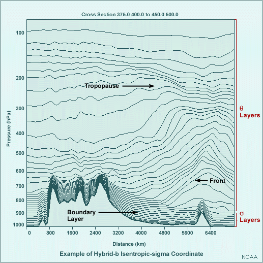
Description:
Hybrid isentropic sigma coordinates
File Name:
rucvert2.gif
Credits:
© The COMET Program
Copyright Terms:
COMET Standard Terms of Use
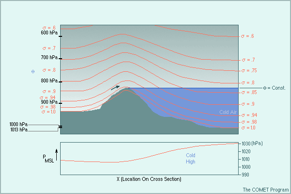
Description:
Cold air damming and sigma coordinates
File Name:
sigflush.gif
Credits:
© The COMET Program
Copyright Terms:
COMET Standard Terms of Use
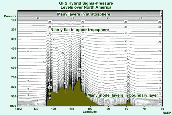
Description:
GFS Hybrid Sigma-Pressure levels over North America
File Name:
sigmaphybridannotate.jpg
Credits:
© The COMET Program
Copyright Terms:
COMET Standard Terms of Use
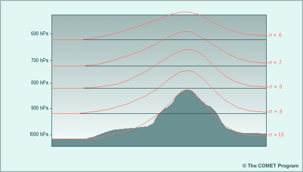
Description:
Sigma coordinates compared to pressure coordinates for a mountain
File Name:
sigmount.gif
Credits:
© The COMET Program
Copyright Terms:
COMET Standard Terms of Use
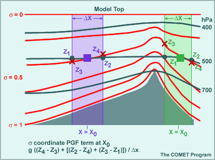
Description:
Calculating pressure gradients in sigma coordinates
File Name:
sigslope.gif
Credits:
© The COMET Program
Copyright Terms:
COMET Standard Terms of Use

Description:
Grid point model temperature
File Name:
tempgrid.jpg
Credits:
© The COMET Program
Copyright Terms:
COMET Standard Terms of Use

Description:
Grid point model temperature
File Name:
tempgrid_question.jpg
Credits:
© The COMET Program
Copyright Terms:
COMET Standard Terms of Use
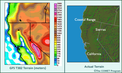
Description:
Model terrain vs actual
File Name:
tercompar.jpg
Credits:
© The COMET Program
Copyright Terms:
COMET Standard Terms of Use
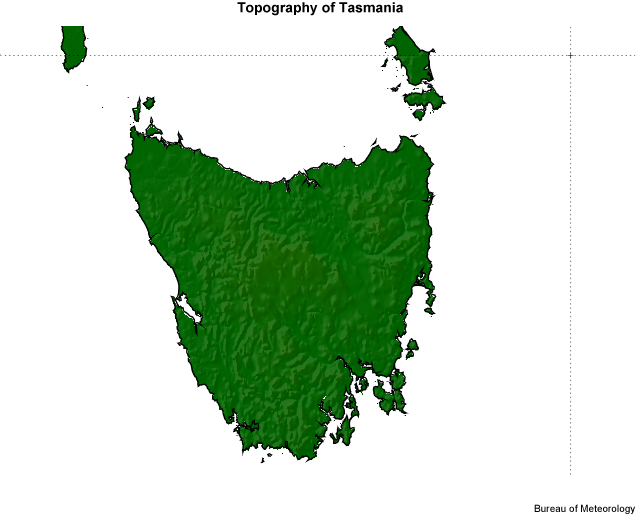
Description:
Topography of Tasmania
File Name:
terrain-tas.jpg
Credits:
Bureau of Meteorology
Copyright Terms:
COMET Standard Terms of Use
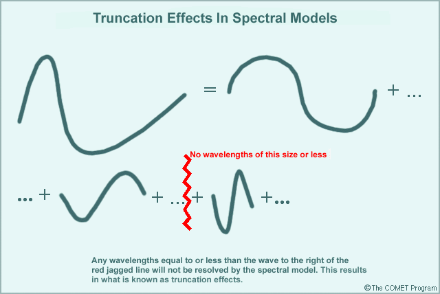
Description:
Truncation effects in spectral models
File Name:
trunca.gif
Credits:
© The COMET Program
Copyright Terms:
COMET Standard Terms of Use
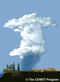
Description:
Precipitating cloud
File Name:
wx_param_plain_cropped.jpg
Credits:
© The COMET Program
Copyright Terms:
COMET Standard Terms of Use