Introduction
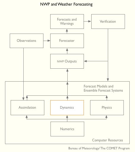
This lesson is focused on how a model forecast and the interpretation of that forecast are affected by the basic design of the model. The content that follows fits under the Dynamics box on the NWP and Weather forecasting chart.
Question 1 of 2
The "model type" refers to whether a model represents meteorological data as point-like (gridpoint) or as a series of waves (spectral), and hydrostatic or nonhydrostatic. Which combination of model types do you think would best be able to explicitly resolve individual thunderstorms?
The correct answer is c.
As we will see shortly, only a non-hydrostatic model can represent the internal pressure gradients and buoyancy effects within a thunderstorm, and hence a) and d) are incorrect. Likewise, spectral models tend to smooth features out too much, such as spreading cold pools. Cold pools often have sharp boundaries, and hence are better represented with gridpoint models with high resolution, and hence b) is incorrect.
Question 2 of 2
The "model type" affects the types of errors the model makes, thus how to interpret the model forecast. See if you can identify some of these influences.
Which of the following are affected by model type? (Choose all that apply.)
The correct answers are a, b, d, e.
Gridpoint and spectral models are based on the same set of primitive equations. However, each type formulates and solves the equations differently. The differences in the basic mathematical formulations contribute to different characteristic errors in model guidance.
The differences in the basic mathematical formulations lead to different methods for representing data. Gridpoint models represent data at discrete, fixed grid points, whereas spectral models use continuous wave functions. Different types and amounts of errors are introduced into the analyses and forecasts due to these differences in data representation.
The characteristics of each model type along with the physical and dynamic approximations in the equations influence the type and scale of features that a model may be able to represent.
Model type does not necessarily impact the size of a model's domain. Global models have historically been spectral because the wave functions and spherical harmonics in the spectral formulation form a natural mathematical basis over a spherical domain, allowing high accuracy in modeling the motion of a fluid on a sphere, such as the atmosphere over the earth. However, global models are increasingly becoming gridpoint as computer resources increase. Nonhydrostatic models are usually limited to small domains because the additional cost of computing the nonhydrostatic terms only helps the forecast of small-scale features requiring high resolution to resolve, and most operational centers don't yet have enough computer power to run a global high-resolution model in real time. However, with increasing computer power, it may only be a matter of time before there are global nonhydrostatic models.
Model type has no direct impact on the choice of horizontal or vertical resolution down to around 10 km horizontal grid spacing. Theoretically, gridpoint and spectral models can be of any resolution, within the limitations of available computing power. However, a model with very fine horizontal resolution should be nonhydrostatic.
After completing this lesson, you will be able to:
- List at least 2 types of weather features which a hydrostatic model of sufficient resolution is not capable of properly predicting because the phenomena are nonhydrostatic in character
- Describe the difference between how a grid point model and a spectral model represent data
- State the primary source of error present in a limited-domain model but not present in a global model, and describe the time evolution of where in the limited-domain model the error appears
- List 2 advantages and 2 limitations of models which use a sigma vertical coordinate or a hybrid which includes sigma coordinates at the bottom of the mode
- State the minimum size feature a gridpoint model can predict well (how many grid boxes wide)
- State at least two impacts of increasing model horizontal resolution on model topography
- State at least two impacts of increasing model horizontal resolution on the resolution of atmospheric features
- State at least 2 types of forecast errors other than temperature errors which occur in complex terrain when the terrain is not adequately resolved
- Describe how the model prediction of boundary layer evolution can be affected by vertical resolution in an area of complex terrain